
Region: Democratic Republic of the Congo (DRC), The Oriental Province
Lead time: 8 months (2011).
Type of mineral: diamonds
Survey area: 385 km2
Objective: Perform exploration of diamond deposits in an area of 385 km2 in the north-east of the Democratic Republic of the Congo using remote sensing and field surveys. Estimate resources and assess the prospects for development.
Brief overview
The study area is characterized by difficult accessibility and considerable remoteness from the objects of civilization. A dirt road with a length of 160 km leads to the study area. The base camp of the expedition can be reached on foot (8-10 hours), either by motorcycle (2 hours), or by boat on the Aruvimi River
(2 hours). The territory of the concession is located within the equatorial belt. The climate is hot, tropical, humidity up to 100%.
The studied territory belongs to the category of unexplored or poorly explored area. There are no medium and large-scale topographic maps, geological data, information about the geological setting is very incomplete, fragmentary. The youngest in the area described are the alluvial quaternary and modern deposits of the XYZ river and its tributaries. They are represented by two types of sediments: channel and floodplain.
Alluvial deposits of the floodplain are usually characterized by a bipartite structure. The upper part with a capacity of up to 4.0–7.0 m is usually represented by sands and loams of gray, light gray and yellowish-gray color with layers of clays and loams of gray and bluish-gray color with a capacity of 5–10 cm. The lower part from a depth of 4.0–7.0 m is represented by gravel-pebble deposits consisting of 70–80% of well-rolled quartz pebbles with rare inclusions of weakly rolled fragments of chocolate-brown argillite and gray sandstones cemented with a sandy loamy matrix of gray or light brown color.
Floodplain sediments are usually littered with whitish or brown saprolites that make up the upper, weathered part of the underlying bedrock.
The results
The commercial diamond content of the channel sediments was confirmed, 34 objects with a total area of 1.3 km2 were identified within the riverbed, two of which, when excavated, proved to be positive.
For the first time, the commercial diamond content of the floodplain deposits was established, where 77 anomalies with a total area of 1.8 km2 were identified, of which 8 objects were excavated and 5 of them received positive results.
Three different methods were used to estimate the resource base of placers of the river. Using statistical correction coefficients, the recoverable reserves of placers were appraised.
Project status
It is not possible to get up-to-date data about the project. No information was found in open sources.
In 2013, an independent examination of the results was carried out, which confirmed that during the exploration enough data was collected to guarantee the further development of the project, and assessed the object as promising, having a solid resource for commercial development.
The Customer’s feedback, as well as the report of the independent company, can be provided upon request.
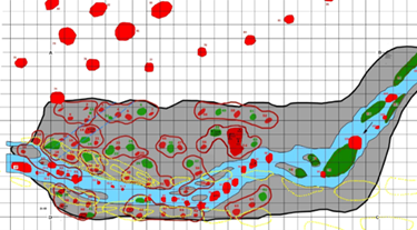
Map of identified anomalies
Source Mineral – Spectrum