
Region: Mongolia
Lead time: 2 years (2012-2013)
Type of mineral: Uranium
Objective: Perform studies of a large, licensed area (S= 29,820 km2) in the north-west of Mongolia using satellite and field exploration tools to identify and delineate zones with uranium manifestations. Select points for drilling exploratory wells on anomalies with maximum uranium concentrations in them.
Geological overview
The area of work, like the entire territory of the north-west of Mongolia, is poorly studied in geological terms. In general, the surveyed license area is part of the North Mongolian uranium bearing area with a known uranium complex deposit (Th–U–Zr–Nb–Ta–Tr) with albitization zones (Khan-Bagda type). Based on the current layout of uranium deposits of the eastern part of the Central Asian mobile belt and adjacent territories (2009), the study area is close to 4 potentially uranium ore zones: Butulinnur, Tsaganshirbaeta, Mongol-Altai and Ozernaya PURZ.
The following (main) types of uranium deposits have been discovered in Mongolia:
- Exogenous uranium objects (deposits resulting from surface manifestations – weathering, precipitation, etc. – 52%.
- Endogenous uranium objects (i. e. internal – associated with tectonics, magmatism, metamorphism and hydrothermal processes) – 21%; promising deposits in the zones of granitic crushing – 12%.; the proportion of other types of uranium ordinance is small and is only 15%.
The area is extremely poorly studied. The identification of uranium ore sites in the area can completely change the adopted scheme. Therefore, it was necessary to look for uranium deposits everywhere, not only in the rocks stereotyped for uranium mineralization, inherent in the already discovered uranium deposits of Mongolia.
Samples
Samples were provided from 3 uranium deposits, in volumes of at least 150 grams each, in sealed packages (made of metal, polyethylene) and with known uranium content and chemical elements in the ores, as well as samples of ores with low uranium content (background values) and with known content of metals in them.
Results
A large area (S= 29,820 km2) was studied. Based on the results of the processing of 11 large-scale satellite images, the boundaries of 4 zones of dispersion halos of uranium minerals with background values of uranium contents at their boundaries were visualized and mapped (CU≈0.02%).
Forty detailed images inside 4 zones of halos, 4 sites with promising uranium anomalies in them, were visualized and mapped (uranium ores content in individual areas within these areas can be 0.03÷0.05% or more) in the amount of 16 pieces and a total primary area of 126.9 km2. In addition, 29 weak uranium manifestations (area 101.3 km2) with a uranium content of < 0.03% (in each of the sites) were outlined. The approximate depths of occurrence of uranium ores in each of the 16 anomalies were estimated.
Thus, as a result of the remote stage, the area of detailed surveys at the identified 4 uranium ore sites was significantly reduced (from 29,820 km2 to 126.9 km2 i.e., more than 200 times).
Another series of detailed satellite photographs (32 pieces) covering each of the 16 uranium anomalies was made. Nine promising anomalies were identified, in which there may be 9 orebodies with commercial uranium content in uranium sites No. 2, No. 3 and No. 4. At site No. 1, all 4 anomalies were assessed as not promising due to the low content of uranium in the ore.
During the period of the survey of all anomalies, the field equipment outlined and identified 9 orebodies with commercial uranium content SUR.>0.05) and clarified their boundaries, measured the depths of occurrence of orebodies at measurement points located on the geological sections of each orebody.
In each anomaly, points were selected for drilling exploratory wells with an indication of uranium concentrations, thickness, and depths of occurrence of orebodies. Uranium content in the orebodies is ranged from 0.05% to 2%. Ores with uranium content >2% were not detected.
Geological sections were built at anomalous sites with 9 mineralizations and the resources of uranium ores and metal in them were estimated.
The orebodies are confirmed at the points selected for drilling wells using electrical exploration equipment (an additional independent search method).
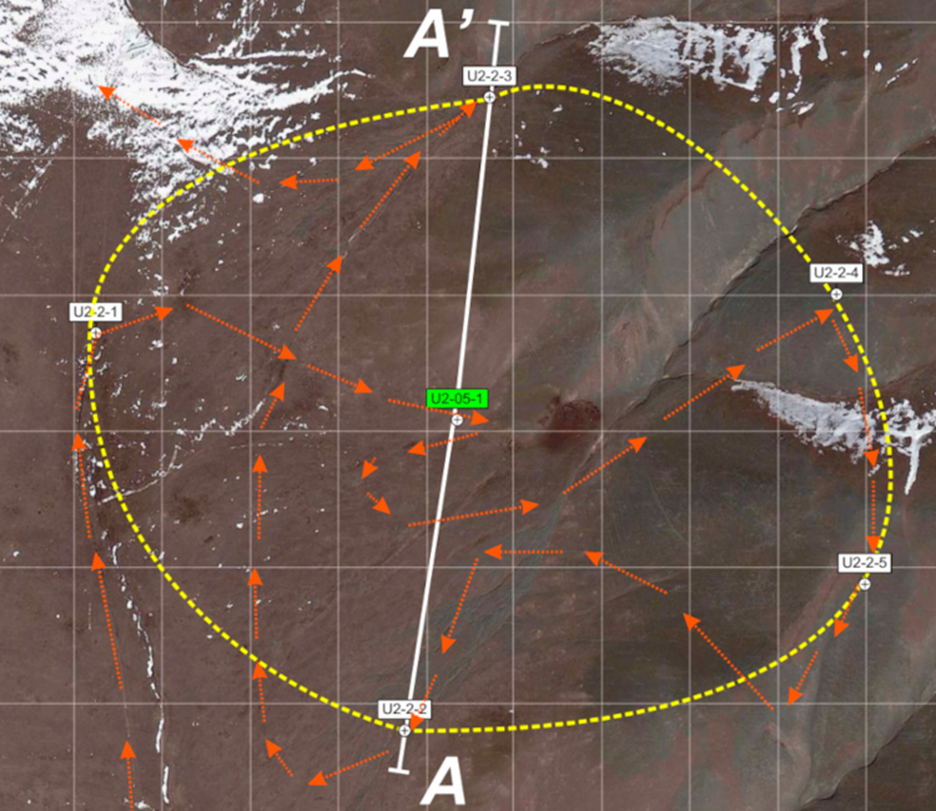
Identified orebodies #U2-05 with commercial uranium content.
The photo shows the route of the orebodies survey, the measuring point with field equipment (U2-2-1, …) the recommended point for drilling (U2-05-1), the deep section (A-A).
Source Mineral – Spectrum