
Location: Indonesia, block Brantas
Lead time: 6 months (2012)
Mineral Type: Oil/Gas/Gas Condensate
Objective: Perform remote sensing survey of the territory with a total area of 3,050 km2 to search for and assess the resources of oil and gas in 2 onshore concessions and in 3 offshore concessions.
Brief geological overview
Earlier, exploratory drilling was carried out on 2 onshore blocks and there were no discoveries of commercial quantities at depths of 850÷900 m (gas), at depths of 980÷1100 m (oil) and at depths of approx. 3000 m (oil). No offshore drilling was at that time, but in the north-east of one of the sites one well hit a trap at 3,900 m depth (product- oil and gas).
Previously, exploratory drilling was carried out on two onshore blocks, as well as north of them, and there are wells with commercial inflows at depths of 850-900 m (gas), at depths of 980-1,100 m (oil) and at depths of approx. 3,000 m (oil). No drilling was in offshore areas, however, an oil and gas trap at depths of 3,900 m (oil and gas mixture) was penetrated by one well to the northeast of one of the sites.
The productive formations are composed of tuff sandstones of Paleogene-Neogene age, formed at depths from ~ 500 m to ~ 1400 m; and from 1600 m to 4100 m (depending on specific areas, including offshore sites).
As a result of active tectonic-volcanic activity, these deposits are folded and complicated by tectonic dislocations, resulting in the formation of horst-graben structures often with unconformity of layers occurrence.
The results
At the first stage, promising hydrocarbon oil and gas anomalies were identified and contoured: oil – 16; gas – 5. The accuracy is estimated at 60-65%.
At the second stage (detailed field survey), measurements were made to clarify the depths and thickness of the oil and gas horizons of each anomaly, deep cross sections of potential HC saturated formations were built, and well locations were selected and substantiated at each promising anomaly. The accuracy was estimated no less than 80-85%, with oil samples – up to 90-95%.
Main results:
- Exact coordinates of each site and their area were determined.
- Average depths of the horizons (three in total) were determined, the deepest of them at 4000 meters.
- Average effective thickness of each reservoir was determined. The biggest thickness of the lower horizon at depths of 3990-4020 m found in two areas was up to 16 m, in other areas it did not exceed 10 m.
- Gas pressure in each gas horizon was determined.
- Migration pathways to the anomalies of each site were identified.
- The most productive horizons for commercial development (8 oil and 6 gas) were located.
- Resources for each identified oil and gas anomaly were estimated.
- Deep sections for each anomaly were constructed.
- Recommended locations for drilling for each site were determined.
Project status
On August 3, 2018, the Indonesian government approved the extension of the mining license for Lapindo Brantas Inc. for another 20 years until 2040.
At the time of the license renewal, gas production ranged from 566 to 707 thousand m3/day. The company planned to increase to 991 thousand m3/day by the end of 2018. Based on the five-year plan, gas production will be about 4.2 million m3/day.
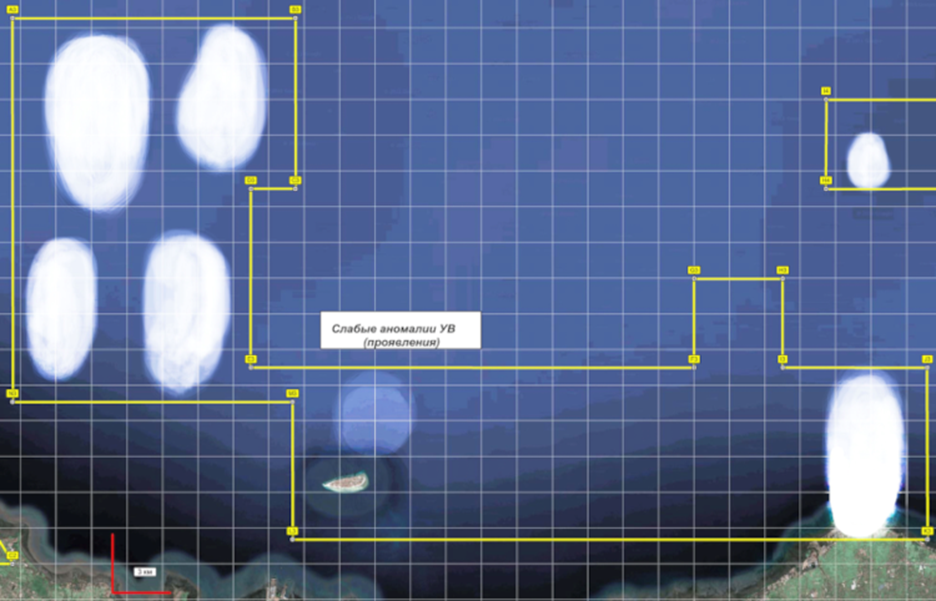
Example of anomalies identified at the first stage. Offshore site

Example of anomalies identified at the first stage. Offshore site
Source Mineral – Spectrum